LiDAR
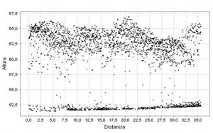
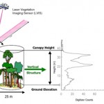
 LiDAR (Light Detection and Ranging) technology is based on coordinates taken over the surface with a laser. The laser can be installed on a plane, and allows the gathering of data over huge extensions really fast. Through LiDAR gives a very accurate model of the terrain, as it not only considers the earth’s surface but the laser bounces on any other cover such as vegetation, with countless applications on the natural environment that this represents in fact.
While LiDAR technology is not available until now extensively throughout the territory, it is forecasted that in the medium term this information will be available for the entire territory. Moreover, further further processing on this cartography requires specific techniques to be used.
BALMA Consulting is working together with other partners in order to develop a specific software that allows the automatic acquisition of fuel models and the quantification of biomass in a given area from LiDAR data. Thus we offer:
- Generation of environmental and forest thematic cartography from LiDAR data, according to the objectives to be achieved.
- Cartographic applications of all types that are derived from the data, as the height of trees, scrub characteristics, geomorphology of terrain, etc